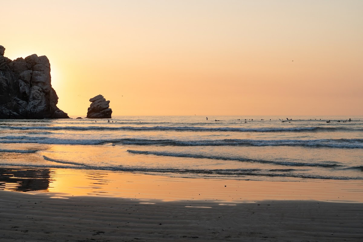
Morro Rock Beach is situated along the edge of Morro Bay in San Luis Obispo County, California, and its identity is largely shaped by the nearby Morro Rock. Morro Rock rises above to roughly 576 feet above sea level and represents the remains of an ancient volcanic feature. The formation stands at the point where the Pacific Ocean meets the Morro Bay estuary creating a strong visual landmark that dominates the surrounding coastal landscape, though the transition between ocean and bay is not sharply defined in all conditions. The beach extends for roughly one mile near the entrance of the bay and consists of a combination of light-colored sand and scattered rocky sections, with exposure to both sheltered bay waters and the open ocean.
The area falls within Morro Bay State Park and is also connected to the Morro Bay National Estuary Program. Management responsibilities are shared between California State Parks and the City of Morro Bay, working alongside the California Coastal Commission. Both the rock and the surrounding shoreline are designated as a California Historical Landmark and hold long-standing cultural importance for the Chumash people, who have historical ties to this landscape.
Because of its setting, the beach draws visitors interested in photography, bird observation, kayaking, and coastal walking rather than typical swimming activity. The dramatic rock formation, combined with estuary views and open Pacific conditions, gives the site a character that is strongly associated with California’s Central Coast, blending natural significance with quiet recreational use.
Unique Feature of Morro Rock Beach
Morro Rock Beach is most clearly characterized by the dominating presence of Morro Rock, a single volcanic formation that has long functioned as a visual marker for navigation and coastal reference. Its tall and isolated shape stands out strongly against both the open ocean and the bay while giving the shoreline quite a distinct and easily recognizable appearance.
Next to Morro Rock, the estuary creates a large wetland area along the Central Coast. This area is home to many migratory birds and marine creatures and plays an important role in maintaining ecological balance, although the line between beach, bay, and wetland can be unclear at times during the year.
Things to Do at Morro Rock Beach
Visitors to Morro Rock Beach can take part in several outdoor and nature focused activities that make use of the beach’s scenery and ecological features. People often walk along the shoreline while exploring the sand and rocks while enjoying views of Morro Rock and the nearby estuary. The Morro Bay Estuary is a good place for birdwatching, as it is on the Pacific Flyway and more than 250 bird species can be seen there during the year.
In the water, kayaking or stand-up paddleboarding is possible in the calmer parts of the bay, and rentals are available from local operators. Tide pooling near the base of the rock during low tide allows visitors to see marine creatures such as hermit crabs, anemones, and other small sea life. Many photographers prefer sunrise or sunset for capturing the rock’s silhouette against the sky.
There are spots for picnicking near the parking lot or on the sand, and nearby trails in Morro Bay State Park give higher views of the coastline and estuary. The Morro Bay Estuary Nature Center shows about the information about local environment and history while helping visitors understand the area more. Visitors also often enjoy watching wildlife, including sea otters, harbor seals and quite other small marine creatures close to the shoreline.
Swimming is allowed at Morro Rock Beach, though it should be done carefully because currents near the rock can be strong, especially at certain tides or rough water. It is recommended that visitors pay attention to posted warnings and check water conditions before going in. Overall, the beach provides a combination of calm exploration, wildlife viewing, and scenic coastal vistas, making it appealing to families, photographers, and nature enthusiasts.
How to Reach Morro Rock Beach
Morro Rock Beach can be accessed using Highway 1:
From San Luis Obispo: About 20–30 minutes by car going north on Highway 1, around 15 miles.
From Los Angeles: Approximately 4–5 hours by car, taking US-101 north to Highway 1.
From San Francisco: Around 4–5 hours by car via US-101 south to Highway 1.
Parking is offered in public lots near the beach and rock entrance, usually costing $5–$10 USD per day (cash or card accepted). These lots can fill up quickly, especially by mid-morning in the summer months.
Best Time to Visit
The best time to visit is usually between March and May or September to November, when the weather is mild, around 55–70 °F (13–21 °C), crowds are smaller, and conditions are good for birdwatching and photography. From June to August, summer is at its peak with warmer temperatures of 65–75 °F (18–24 °C), but more visitors and occasional marine fog can be expected. December to February brings cooler weather, about 50–65 °F (10–18 °C), with occasional storms, though clearer skies may give dramatic waves and more visible bird activity.


