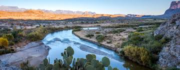
Big Bend National Park sprawls where the Rio Grande hooks a sharp turn through desert flats and jagged peaks—a raw slab of land carved by wind and water. Tucked in Texas’ far southwest, it’s a place of stark solitude, where ancient rock meets sprawling sky, and traces of forgotten folk mingle with the howl of the wild. Its trails crunch underfoot, its canyons echo with stillness, and its edges hold secrets older than any map drawn. This ain’t a spot that just sits—it pulls you deep, makes you face its vast stretch and untamed breath.
A Queer Mark: Each spring and fall, nigh on 300 bird kinds—bright warblers to sharp hawks—flock through Big Bend, one of the top bird haunts in the States, tying its rough sprawl to the sky’s restless drift.
Places to Visit: An Overview
Big Bend rolls out a rugged spread, each corner with its own bite. Santa Elena Canyon cuts a sheer gash—1,500-foot limestone walls tower over the Rio Grande, a slim trail hugging the river’s edge. Paddle it if the water’s up; it’s tight and still.
Chisos Basin, park’s heart, sits high—5,400 feet, ringed by peaks like Casa Grande, cool pines breaking the desert glare. Lost Mine Trail climbs from here—five miles round, a haul to a ridge where Mexico’s hills blur into dust.
Boquillas Canyon gapes east—river squeezes through cliffs, a path tracing the bank, hot springs bubbling near if you’re game to soak. Ross Maxwell Scenic Drive winds west—40 miles of tar past volcanic humps and old homesteads, ending at Santa Elena’s mouth.
Sam Nail Ranch, a broke-down spread from 1916, sits quiet—windmill creaks, cottonwoods shade, a speck of man’s try against the wild. Grapevine Hills—short trek to a rock hump called Balanced Rock, stone piled odd by time’s slow grind.
How to Reach
Big Bend ain’t quick to hit. Nearest airstrip’s Midland/Odessa International Airport (MAF), 200 miles northeast—flies from big hubs like Dallas. Rent wheels there; cabs or shuttles don’t run this far. Closest town’s Marathon, 70 miles north—gas up, stock grub, then roll south on Highway 385 to the park gate.
No trains touch here—Amtrak’s nearest is Alpine, 100 miles off, on the Texas Eagle line from Chicago to the coast. Greyhound skips it too—Alpine’s your drop, then rent or hitch. Highway 90 skirts south from San Antonio, 400 miles—hook 385 at Marathon; it’s a lone haul, sun baking the tar.
Inside, you’re on your own—park’s 800,000 acres got scant roads. Park shuttles run sparse—Chisos Basin to trails some days. Feet or a tough rig’s best; dirt tracks like River Road chew tires if you ain’t ready.
Frequently Asked Questions About Big Bend’s Wildlife
Big Bend’s critters roam free, a thread through its stone, and folks often ask:
What’s creeping round?
Mountain lions stalk quiet—rare seen, but there. Black bears, maybe 30, prowl the Chisos; javelinas root low, pigs with a stink.
Birds worth a look?
Hundreds—colima warblers hit spring, only here in the States. Roadrunners dart, peregrines dive; bring binoculars or miss ‘em.
Snakes a worry?
Rattlers coil—diamondbacks, mojaves. Stick to paths, watch steps; they don’t chase but bite if cornered.
Any night prowlers?
Coyotes yip after dark, gray foxes skulk. Stars pull bats—Mexican long-nosed ones swarm sotol blooms come summer.
When’s it liveliest?
Spring—birds flood, bears wake. Fall cools it; winter’s thin but hawks hang. Summer fries—critters hide ‘til dusk.
Past the Open Stretch
Old Scraps
Hot Springs Historic District—cracked bathhouse from 1900s, mineral pools still steam by the river. Mariscal Mine, south end—cinnabar pits from 1900, mercury dug ‘til ‘43, shacks rotting quiet.
Wild Cuts
Ernst Tinaja, near the park’s east—short hike to a rock tank, water trapped in stone, colors streaked from eons back. Terlingua Ghost Town, just west—old miners’ haunt, adobe husks, cemetery stark under desert sun.
Night’s Pull
Chisos Basin Campground—high perch, stars thick as gravel, no city glow to muck it. Rio Grande Village, low east—river mutters, cooler air off the water, tents catch the quiet.
Side Tracks
Dagger Flat Auto Trail—7 miles of dirt, yucca spikes bloom big every few years. Mule Ears Peaks—twin rock stubs, trail loops 4 miles, desert flat and lonesome.
Farther Reach
Big Bend Ranch State Park, west neighbor—more raw, 300,000 acres, Sauceda bunkhouse if you’re staying. Marfa, 100 miles north—art digs and mystery lights, balls of glow folks can’t pin. Lajitas, southwest—river outpost, golf if you’re odd, or rafts down the Rio Grande. Pine Canyon Trail—back in Big Bend, 4 miles to a waterfall, dry most times but rock holds its own tale.
Handy Know-How
Layover Spots
Chisos Mountains Lodge, Basin’s lone roof—plain rooms, peak views, book early. Terlingua motels, outside west—rough, close, Starlight Theatre bar nearby. RV camps, Rio Grande Village—hookups scarce, bring your own juice.
Grub to Snag
Chisos Basin eatery—burgers, chili, fuel for trails. Terlingua’s Chili Cook-Off, November—pots of heat if you time it. Pack your own—no stores inside, Marathon’s last stop.
When to Roll
Spring, fall—air’s kinder, birds and blooms hit. Winter’s chill but clear; summer burns—110°F, trails empty ‘til night.
Last Reckoning
Big Bend straddles where old crust meets wide open—rock and hush in a hard sprawl. Throws you a wind, a track, a star—says take it. Santa Elena’s steep, Chisos breathes, past rough and broad, now still and stirring. Birds cut, winds howl, and what’s out there stays raw and deep—a Texas wild every step scars fresh.
