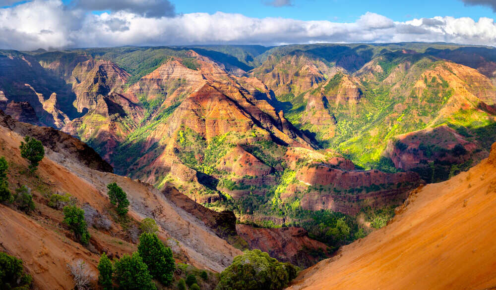
Waimea Canyon, located on the west side of Kauai, is 14-mile-long, 1-mile-wide, and over 3,600-foot-deep geological marvel, often referred as the “Grand Canyon of the Pacific.” Within Waimea Canyon State Park, which spans 1,866 acres, the canyon offers scenic drives, lookouts, hiking trails, and glimpses of Kauai’s rugged interior. This guide outlines the canyon’s history and key places to visit, with practical details for planning a trip.
History of Waimea Canyon
The canyon’s history is rooted in Kauai’s volcanic origins which was formed about 5 million years ago, and is the oldest of Hawaii’s main islands. Waimea River shaped the Waimea Canyon, fueled by intense rainfall from Mount Wai‘ale‘ale, which is among the wettest places on earth. It took over millions of years, the river’s erosion, combined with a significant volcanic collapse 4 million years ago, sculpted the canyon’s sharp cliffs and deep valleys. The name “Waimea,” meaning “reddish water,” comes from the red tint of the water, caused by iron-rich soil washing into the river.
Places to visit
Waimea Canyon Lookout
Past mile marker 10 on Highway 550, Waimea Canyon Lookout is the main spot to see the canyon, marked on the Waimea Canyon map. It shows red and green cliffs dropping over 3,600 feet into deep valleys. The rocks have layers from old volcanic eruptions, and some green plants grow on the slopes. You might see wild goats on far-off cliffs. The open area is great for pictures of the canyon’s big size and bright colors.
Pu‘u Hinahina Lookout
Between mile markers 13 and 14, Pu‘u Hinahina Lookout, shown on the Waimea Canyon map, focuses on the Waimea River flowing through the canyon’s steep sides. The red soil stands out against green plants. On clear days, you can see Ni‘ihau island far away. A short path nearby shows part of Waipo‘o Falls, where water flows down a rocky cliff. This spot feels calmer and lets you see the canyon’s details up close.
Kalalau Lookout
At mile marker 18, Kalalau Lookout, marked on the Waimea Canyon map, looks out over the Kalalau Valley on the Na Pali Coast, not the canyon itself. At 4,000 feet high, it shows sharp cliffs and the Pacific Ocean. The Na Pali Coast has pointy ridges shaped by wind and waves, different from the canyon’s wide valleys. Sometimes mist floats through, making it feel special. It’s a great place to see Kauai’s wild coast.
Pu‘u o Kila Lookout
At mile marker 19, where Highway 550 ends, Pu‘u o Kila Lookout, on the Waimea Canyon map, has the best views of the Na Pali Coast and Kalalau Valley. You see cliffs, green valleys, and the ocean stretching far out. Waves hit rocky shores below, and the scene feels untouched. It’s a quiet spot to take in Kauai’s natural beauty, where the land, sea, and sky come together.
Canyon Trail to Waipo‘o Falls
Starting near the Halemanu trailhead off Koke‘e Road, the Canyon Trail to Waipo‘o Falls, noted on the Waimea Canyon map, is a 3.4-mile hike into the canyon. It goes through forest to the 800-foot Waipo‘o Falls, where water pours down a red rock wall into a misty pool. The trail shows the canyon’s rocky layers, and you might see birds like the ‘apapane. It’s a good way to get close to the canyon’s beauty.
Cliff Trail
Also at the Halemanu trailhead, the Cliff Trail, shown on the Waimea Canyon map, is a short 0.2-mile hike along the canyon’s edge. It shows red and brown cliffs falling into green valleys, with wild goats on slopes. The open path lets you see how water and wind shaped the land over time. It’s an easy way to feel the canyon’s size without a long walk.
Koke‘e State Park
Next to Waimea Canyon State Park, Koke‘e State Park, from mile markers 15-19 on the Waimea Canyon map, covers 4,345 acres of forest and hills. At 3,600 feet, it’s cooler and has trees like koa and ‘ōhi‘a. The Koke‘e Natural History Museum, near mile marker 15, explains how the canyon formed and shows plants and animals, like rare birds such as the ‘i‘iwi. The park’s trails go through wet forests, adding to the canyon’s story with Kauai’s nature.
Iliau Nature Loop
Near mile marker 9, the Iliau Nature Loop, a 0.3-mile trail on the Waimea Canyon map, goes through open land. It features the iliau plant, a rare plant only found on Kauai, and signs about local plants. The trail also gives partial views of the canyon’s red cliffs and nearby hills.
For a successful trip, start early, around 7-8 AM, to avoid crowds and clouds at higher lookouts. Drive Highway 550 from Waimea town; the road is paved but curvy, so take it slow. You can fill up gas in Waimea, as no stations exist along the route. Bring cash for entry fees, water, snacks, and layers, as temperatures range from the mid-60s to mid-70s and cool off at night. Check weather at the Koke‘e Natural History Museum, as rain affects trails. Drones are banned, and visitors should avoid disturbing wildlife or plants.
Conclusion
Waimea Canyon is a unique terrain that shows Kauai’s ancient volcanic past and natural beauty. Lookouts like Waimea Canyon and Pu‘u o Kila show its huge cliffs and ocean views, while trails like the Canyon Trail to Waipo‘o Falls bring you closer to its heart. Koke‘e State Park and the Iliau Nature Loop add stories of plants and animals. Using a Waimea Canyon map, you can explore this sacred land, learning about Native Hawaiian traditions and the forces that shaped it. The canyon’s wild beauty makes it a must-see for anyone wanting to know Kauai’s story.


